
Niutitang Fm
Type Locality and Naming
The type locality of the Niutitang Formation lies about 30 km northwest of the seat of Zunyi City. No type section was assigned by Liu (1942) when he proposed the unit. An auxiliary section, the Yankong section, was proposed by Yin in Dong (1997) as representative section of the formation. It is the lower portion of the same auxiliary section for overlying Mingsinssu Fm and Chintingshan Fm. The section lies near Yankong Town in Yankong Township, about 11 km northeast of the seat of Jinsha County, Bijie City, western Guizhou Province (106°16’E, 27°34’N), and was remeasured by No.1 Brigade of Guizhou Regional Geological Survey Team in 1974. The Niutitang Formation was named by Liu (1942). The name is derived from Niutitang Village, Zunyi City, north-central Guizhou Province. Originally it was called Niutitang Black Shale (Liu, 1942) or Niutitang Shale (Liu, 1948) and was renamed Niutitang Formation by Lu (1962), which has been widely used by subsequent authors.
Lithology and Thickness
The Niutitang Formation is a fine clastic sequence. Lower part consists of black carbonaceous shale. Middle and Upper parts are black carbonaceous shale, intercalated with greyish green carbonaceous siltstone and silty mudstone. In some localities the formation bears black siliceous shale and black siliceous rock at the base. In the type section, the Niutitang Formation is 125.1 m thick.
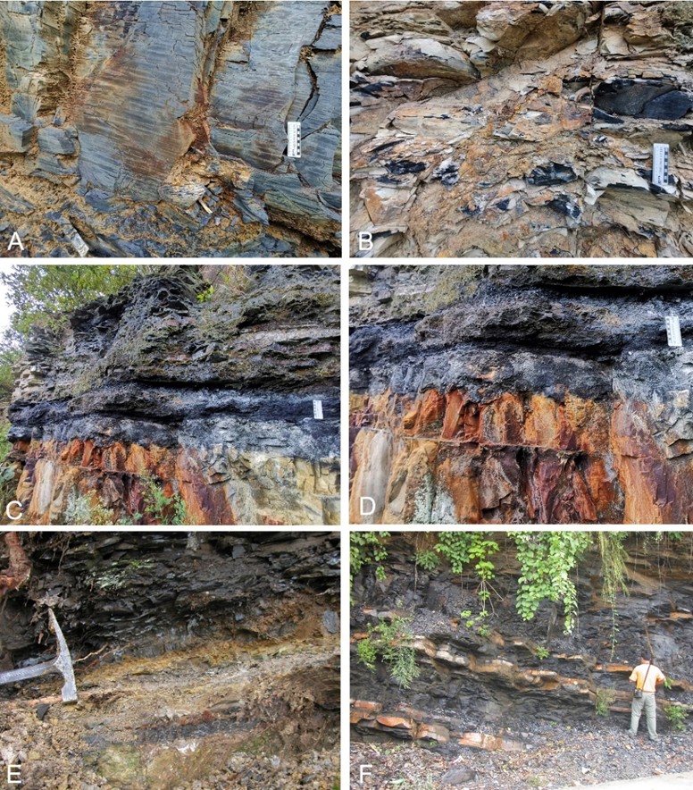
[Figure: Outcrop and lower contact relationship of Niutitang Fm, A-D from Heishapo section, Songlin, Zunyi, north-central Guizhou Province, South China; E, F from Yanjiahe and Huangshandong section respectively, eastern Yangtze Gorge, western Hubei Province, South China. A, B. black shale in lower part of the Niutitang Fm; C, D. disconformable contact between Töngying Fm and the Niutitang Fm. The Töngying Fm consists of greyish brown siliceous dolomite and Fm (below) and thin, reddish brown, limonite-bearing weathered layer (low-middle), lying between the phosphorite and the black shale; Niutitang Fm consists of black siliceous shale intercalated chert bands (above) (photographs supplied courtesy of Mr. Chen Zhengpeng); E, disconformable contact between Töngying Fm and the Niutitang Fm; F, outcrop of lower part of the Niutitang Fm.]
Relationships and Distribution
Lower contact
The Niutitang Fm is in conformable or disconformable contact with either the underlying Töngying Fm or Liuchapo Fm respectively. The lower boundary of the formation is defined by disappearance of the black phosphorite or siliceous rock of the underlying Tongying Fm and of the Liuchapo Fm respectively.
Upper contact
It is conformably overlain by the Mingsinssu Fm in western Guizhou Province, by the Balang Fm or Jiumenchong Fm in eastern Guizhou and western and northwestern Hunan or by the Shipai Fm in western Hubei Province. The upper boundary is defined by the disappearance of its black carbonaceous shale and the appearance of grey mudstone at the base of the Mingsinssu Fm, or appearance of light grey or green shale of Balang Fm, or appearance of yellowish green claystone of Shipai Fm.
Regional extent
The Niutitang Formation is widely exposed in the Yangtze, Jiangnan Slope, and Jiangnan Basin areas of the South China Region, distributed in northern and eastern Guizhou, central, western and northwestern Hunan, northeastern Sichuan, southern Shaanxi provinces and eastern Chongqing Municipality. Drill holes reveal it is buried underground in southern Sichuan. The formation is stable in lithology and its thickness, ranging from 100‒200 m in general, gets thinner from south to north progressively. The formation is observed a maximum thickness, about 200 m, in Qingzhen City (county level), Guiyang City, central Guizhou Province, about 170 m at Yankong of Jinsha County, north-central Guizhou, about 168 m at Yangjiaping of Shimen County, northwestern Hunan, and about 17‒26 m at Shipai, Yichang City, western Hubei and at Pengshui and Shizhu, eastern Chongqing. Some exception in thickness happens in southern Shaanxi, where the formation is reported about 470 m thick at Xinglong, Zhenba County and over 760 m thick at Jixingling, Zhenping County.
GeoJSON
Fossils
Age
Depositional setting
The formation represents anoxic sediments formed in rather deep water and is assigned to transgressive facies.
Additional Information